A good understanding of the weather is a vital skillset for the agricultural drone pilot. In this article we will dig a little deeper into meteorology, advancing your understanding beyond the basic RePL.
The Atmosphere
The atmosphere is a mixture of gases that surround the Earth. This blanket of gases provides protection from ultraviolet rays as well as supporting human, animal, and plant life. Nitrogen accounts for 78% of the gases that comprise the atmosphere, while Oxygen makes up 21%. Argon, Carbon Dioxide, and traces of other gases make up the remaining 1%.
Our focus is on the water vapour contained within the atmosphere. At approximately 3% concentration, water vapour is responsible for ALL the weather phenomena around the globe.
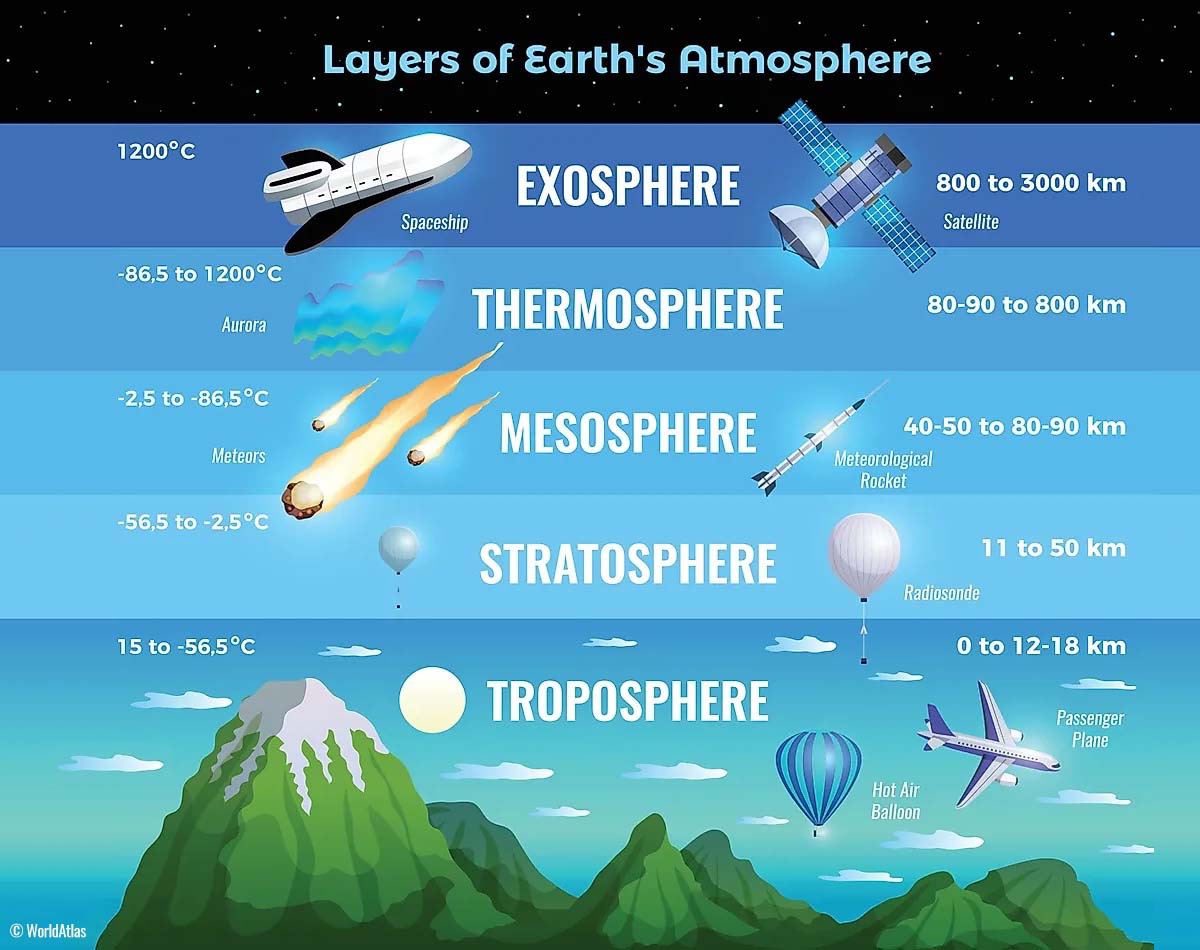
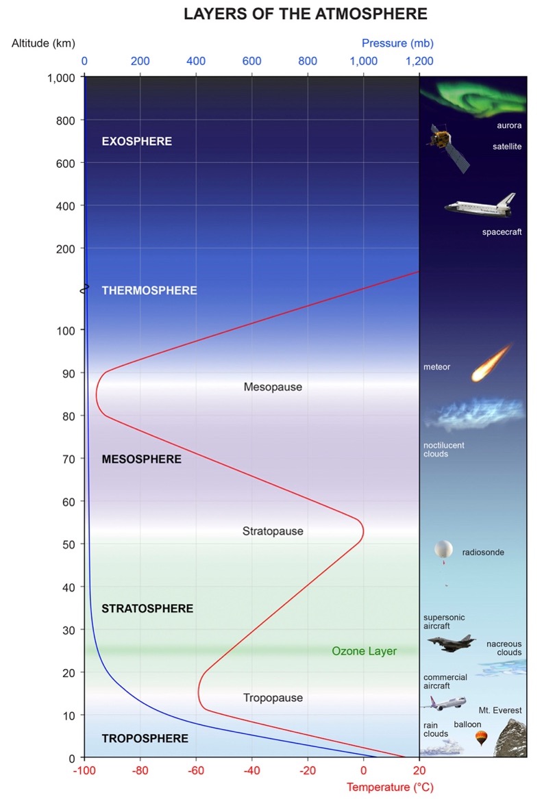
The atmosphere of the Earth may be divided into several distinct layers, as you can see in the following diagram.
The Troposphere
The troposphere, a region of rising and falling pockets of air, is where all weather takes place. The pressure at the top of the troposphere is only 10% of that at sea-level (0.1 atmospheres). There is a thin buffer zone between the troposphere and the next layer – the stratosphere – called the tropopause.
NOTE: As far as aviation is concerned (with the exception of space flight), all activity happens in the troposphere and stratosphere regions.
Temperature in the Layers
In the troposphere, the temperature generally decreases with increasing height at a steady 2°C for every 1000ft of height gained. This continues up to the tropopause (the top of the troposphere) at nearly 36,000 feet. The global temperature average is 15°C near the surface and -57°C at the tropopause.
The layer ends at the point where the temperature no longer varies with height. This is what defines the tropopause, and marks the transition to the stratosphere.
The atmosphere is heated from the re-radiation of heat absorbed by the earths surface from the sun.
Atmospheric Circulation
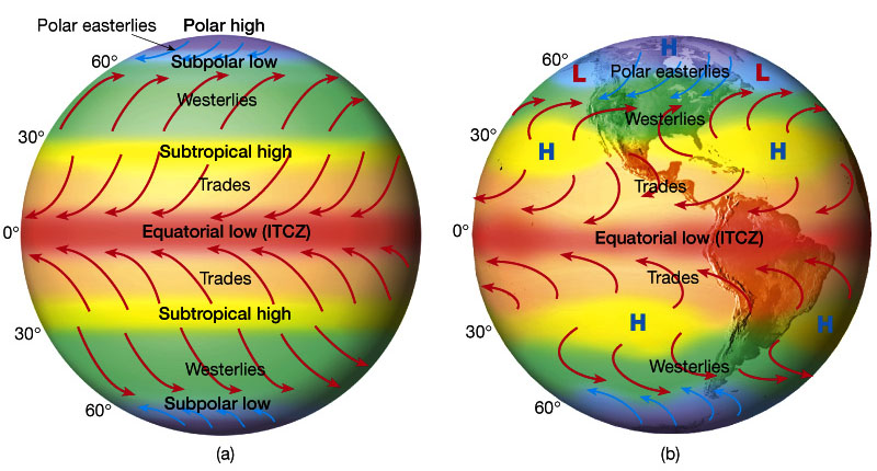
The image above shows the prevailing global winds. The image on the left is the idealised version of wind patterns if all other influencing factors were removed. The image on the right shows a more realistic view where land masses and ocean currents help to shape the flow of wind.
Pressure and temperature changes produce two kinds of motion in the atmosphere: Vertical movement of ascending and descending air currents, and horizontal movement in the form of wind.
Both types of motion in the atmosphere are important as they affect the take-off, landing, and cruise performance of aircraft in operation. More importantly, these motions in the atmosphere (otherwise called atmospheric circulation), cause changes in the weather.
The Cause of Atmospheric Circulation
Atmospheric circulation is the movement of the air around the surface of the Earth. It is caused by uneven heating of the Earth’s surface, which upsets the equilibrium of the atmosphere creating changes in air movement and atmospheric pressure.
Because the Earth has a curved surface that rotates on an axis while orbiting the sun, the equatorial regions of the Earth receive a greater amount of heat from the sun than the polar regions. The amount of sunlight that heats the Earth depends on the time of day, time of year, and the latitude of the specific region. All these factors affect the length of time and the angle at which sunlight strikes the surface.
In general circulation theory, areas of low-pressure exist over the equatorial regions, and areas of high-pressure exist over the polar regions due to the difference in temperature. Solar heating causes air to become less dense and rise in equatorial areas. The resulting low-pressure allows the high-pressure air at the poles to flow along the planet’s surface towards the equator. As the warm air flows back towards the poles it cools, becomes denser, and sinks back towards the surface.
This pattern of air circulation is correct in theory however, the circulation of air is modified by several forces, most importantly the rotation of the Earth itself – an effect called the Coriolis Force.
Wind
Wind is caused by air flowing from high-pressure areas to low-pressure areas. Since the Earth is rotating, the air does not flow directly from high- to low-pressure, but is deflected to right in the northern hemisphere, and to the left in the southern hemisphere. This is the Coriolis Effect, causing the wind to flow mostly around the high- and low-pressure systems.
This effect of the wind “feeling the Earth turn underneath it” is important for very large and long-lived pressure systems. For small, short-lived system, such as in the cold outflow of a thunderstorm, the wind will flow directly from high- to low-pressure. That said, this rotational effect can still be witnessed on a smaller scale in weather phenomena such as tornadoes and dust devils.
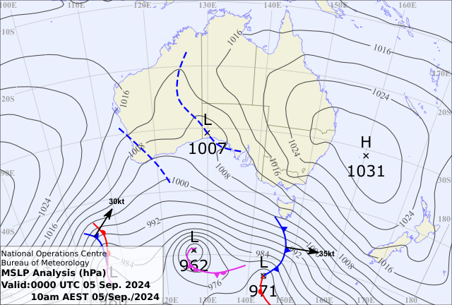

The closer the high- and low-pressure systems are together the stronger the pressure gradient, and therefore the stronger the winds. On weather maps (also know as Synoptic Charts), lines of constant pressure are drawn (as in the example above) which are called isobars. These isobars are usually labelled with their pressure value in millibars (mb). The closer these lines are together, the stronger the wind.
The curvature of the isobars is also important to the wind speed. Given the same pressure gradient (isobar spacing), if the isobars are curved anti-cyclonically around the high-pressure in the image above the wind will be stronger. If the isobars are curved cyclonically (as around the low-pressure in the image above) the wind will be weaker.
Near the surface of the Earth, friction from the ground slows the wind down. During the day, when convective mixing is stirring up the lower atmosphere, this effect is minimised. At night, when the convective mixing has stopped, the surface wind can slow considerably or even stop altogether.
Wind can be thought of one way that the atmosphere moves excess heat around. Directly or indirectly, wind forms the primary purpose of helping to transport excess heat either away from the surface of the Earth where sunlight causes an excess of energy build-up, or from warm regions (usually the tropics) to cooler regions (usually the higher altitudes).
Wind Direction
Air flows from areas of high-pressure into those of low-pressure because air always seeks out lower pressure.
In the southern hemisphere, this flow of air is deflected to the left, producing an anticlockwise circulation around an area of high-pressure – known as the anti-cyclonic circulation. The opposite is true of low-pressure areas; the air flows toward a low and is deflected to create a clockwise, or cyclonic circulation.
High-pressure systems are generally areas of dry, stable, descending air. Good aviation weather is typically associated with high-pressure systems for this reason.
Conversely, as air flows into low-pressure systems to replace the rising air, the air tends to be unstable, bringing increasing clouds and precipitation. Thus, bad or hazardous aviation weather is commonly associated with areas of low-pressure.
A good understanding of high-and low-pressure wind patterns can be of great help when planning a flight as the pilot can take advantage of beneficial tailwinds.
Convective Currents
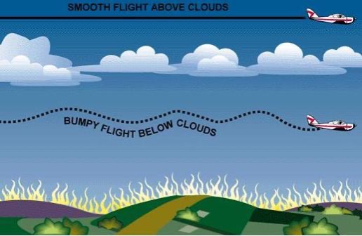
Different surfaces radiate heat in varying amounts. Bare earth, rocks, sand, and barren land give off a large amount of heat. Water, trees, and other areas of vegetation tend to absorb and retain heat. The resulting uneven heating of the air creates small areas of local circulation called convective currents.
Convective currents is what causes the bumpy, turbulent air sometimes experienced when flying at lower altitudes during warmers weather.
On a low-altitude flight over varying surfaces, updrafts are likely to occur over pavement or barren earth, and downdrafts often occur over water or expansive areas of vegetation like a group of trees. Typically these turbulent conditions can be avoided by flying at higher altitudes, even above cumulus cloud layers.
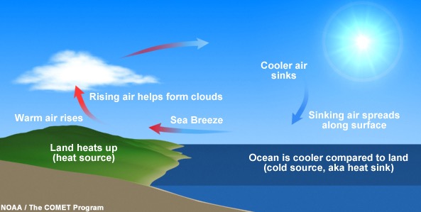
Convective currents are particularly noticeable in areas with a landmass directly adjacent to a large body of water, such as an ocean, large lake, or other appreciable area of water. During the day, land heats faster than water, so the air over the land becomes warmer and less dense. It rises and is replaced by cooler, denser air flowing in from over the water. This causes an onshore wind, called a sea breeze. Conversely, at night land cools faster than water, as does the corresponding air.
In this case, the warmer air over the water rises and is replaced by the cooler, denser air from the land, creating an offshore wind called a land breeze. This reverses the local wind circulation pattern. Convective currents can occur anywhere there is an uneven heating of the Earth’s surface.
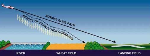
Convection currents close to the ground can affect a pilot’s ability to control the aircraft. On final approach, for example the rising air from terrain devoid of vegetation sometimes produces a ballooning effect, which may force a pilot to overshoot the intended landing spot. On the other hand, an approach over a large body of water or an area of thick vegetation tends to create a sinking effect that can cause an unwary pilot to land short of the intended landing spot.
Effect of Obstructions on Wind
Another atmospheric hazard exists that can create problems for pilots. Obstructions on the ground affect the flow of wind and can be an unseen danger. Ground topography, vegetation and large buildings can break up the flow of wind and create wind gusts that change rapidly in direction and speed.
These obstructions range from man-made structures like hangars to large natural obstructions, such as mountains, bluffs, or canyons. It is especially important to be vigilant when flying in areas where obstructions are in and around the flight area.
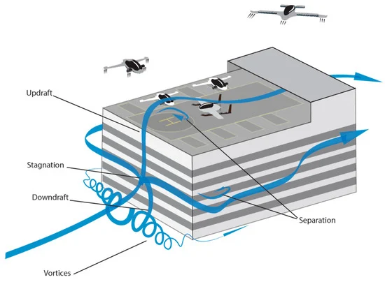
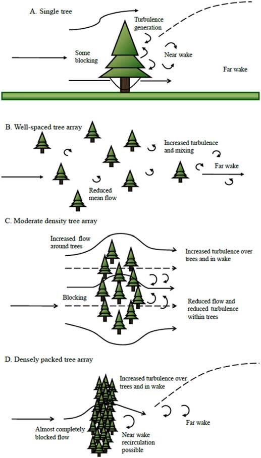
The intensity of turbulence associated with ground obstacle obstructions depends on the size of the obstacle in the primary velocity of the wind. This can affect the take-off and landing performance of any aircraft and can represent a very serious hazard. During the landing phase of flight, an aircraft may “drop-in” due to the turbulent air and be too low to clear obstacles during the approach.
This same condition is even more noticeable when flying in mountainous regions.
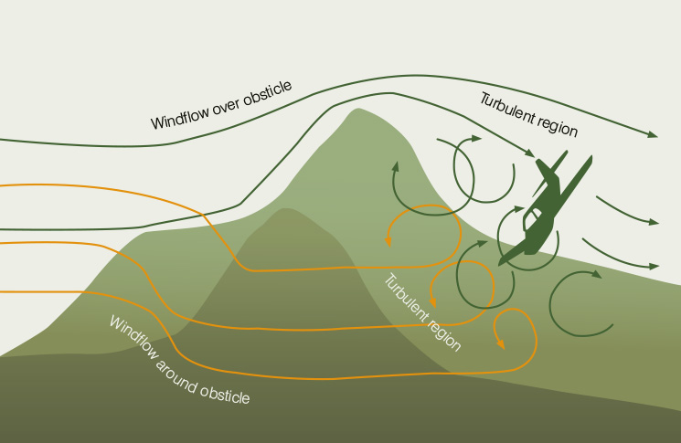
While the wind flows smoothly up the windward side of the mountain and the upward currents help to carry an aircraft over the peak of the mountain, the wind on the leeward side does not behave in the same smooth manner.
As the air flows down the leeward side of the mountain, the air follows the contour of the terrain and is increasingly turbulent. This tends to push an aircraft into the side of the mountain. The stronger the wind, the greater the downward pressure and turbulence increases.
Due to the effect terrain has on the wind in valleys or canyons, downdrafts can be severe. Thus, all operations on the downwind side of the mountain should be treated with great caution, avoiding very windy conditions.
Anabatic and Katabatic Winds
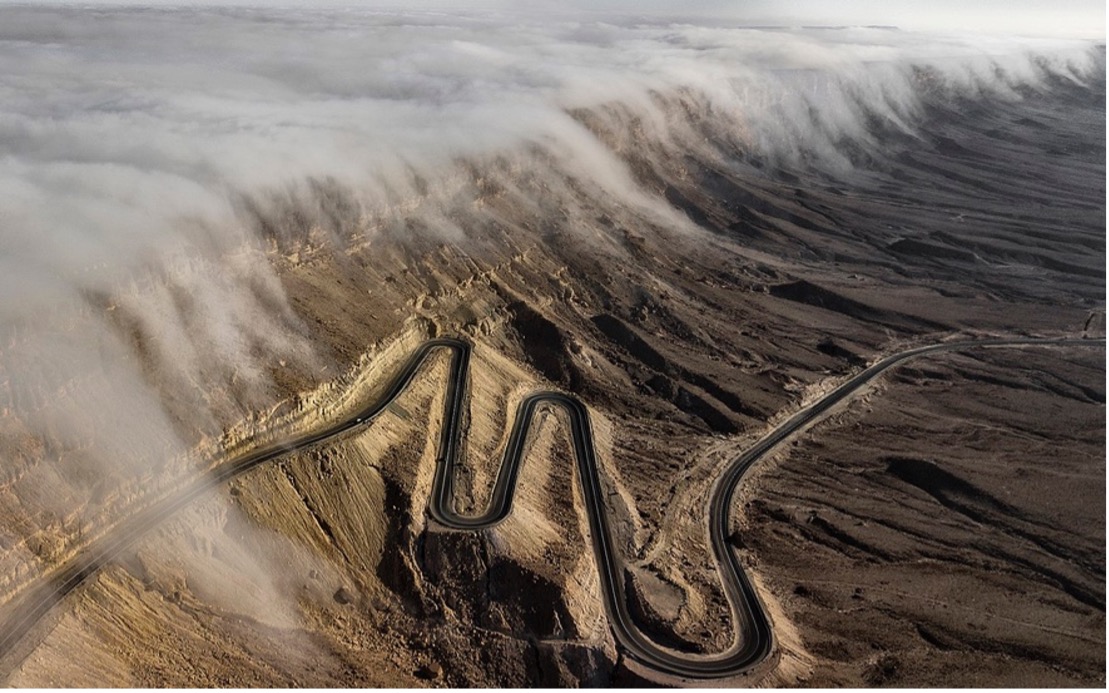
Anabatic and Katabatic winds are induced thermally. Anabatic upslope winds occur over slopes which are heated by the sun. Katabatic downslope winds occur over slopes which are cooled.
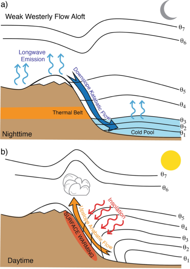
Katabatic Winds
Figure A in the above illustration is an example of katabatic winds.
Katabatic winds occur where air in contact with sloping ground is colder than air at the same level away from the hillside over the valley.
Surface cooling generally results from a net loss of radiation at night, particularly where skies are clear of cloud. Accordingly, katabatic winds are nocturnal phenomena in most parts of the world, their speeds typically not exceeding 3 or 4 m/s. Where ground is covered with snow or ice however, katabatic winds can occur at any time of day or night their speeds often reaching 10 metres per second or even more if funnelling through narrow valleys.
Anabatic Winds
Figure B in the above illustration is an example of anabatic winds.
Anabatic winds are usually very light (generally only 1 or 2 m/s) and seldom of much significance, except near the coast, where they tend to augment sea breezes. In contrast, katabatic drainage may lead to the formation of frost, mist and fog in valleys.
Low-Level Wind Shear
Wind shear is a sudden, drastic change in wind strength and/or direction over a very small area.
Wind shear can subject an aircraft to violent updrafts and downdrafts as well as abrupt changes to the horizontal movement of the aircraft. While wind shear can occur at any altitude. Low level wind shear is especially hazardous due to the proximity of an aircraft to the ground.
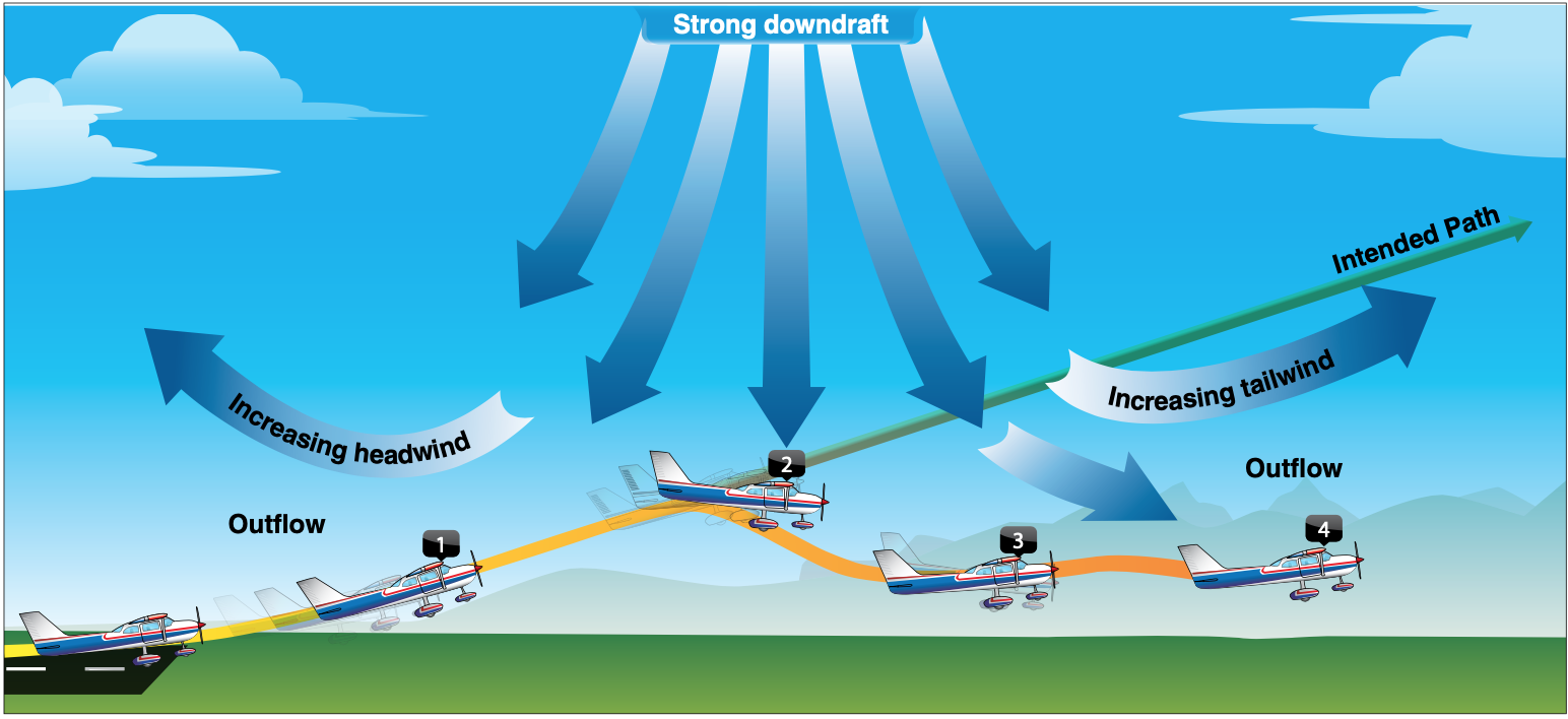
During a wind shear event, the effects can be subtle or very dramatic depending on the wind speed and direction of change. Directional wind changes of 180° and speed changes of 50 knots or more are often associated with low level wind shear. Low level wind shear is commonly associated with passing frontal systems, thunderstorms, and temperature inversions with strong upper-level winds greater than 25 knots.
In general, the most severe type of low-level wind shear is associated with convective precipitation or rain from thunderstorms.
Conclusion
A good understanding of the weather is a vital skillset for the agricultural drone pilot. Although a lot of the content of this article is taken from, and directed at pilots of manned aircraft, by developing an appreciation of not only what is happening in the atmosphere but why it is happening we can become better at planning agricultural operations.
Understanding air movement in the troposphere affects not only how and where we fly our aircraft, it also has an impact on how we manage buffer zones, spray drift, and even the speed and height at which we operate.
Let’s Get Started
Don’t trust your future to anyone else. FPV Australia have you covered. Contact us NOW!

