A detailed property map can make the flight planning process a lot easier, especially in difficult and remote access areas.
Introduction
The concept of a Job Safety Assessment (JSA) should be familiar to all RePL licensed RPA operators. Property planning is simply an extension of this procedure, allowing the agricultural drone operator to identify risks within the treatment area particular to the application of pesticides during low level flight.
Why Map?
Creating maps for property planning can range from the simplest hand-sketched “mud map” to a fully annotated digital satellite image. Whichever method an operator chooses to use, the map needs to contain sufficient detail and accuracy of information to allow risks to be translated to automated flight management software (such as DJI Terra or XAG One).
Some of the reasons for creating a property plan can include:
- Critical analysis for use during risk assessment of the treatment area specifically targeting obstacles, no-fly zones, and surrounding sensitive areas that may be affected by chemical application.
- Highlighting dangerous areas for operators such as undulating terrain.
- Determine the size, scope, and spread of invasive weeds where applicable.
- Determine operational logistics such as time required to complete operation, and amount of product and water required.
- Legal requirements – Who an operator might need to notify about an aerial chemical application.
 Treatment Area Considerations when Mapping
Some of the things that you should be looking for and marking onto your property plan during this process include:
- Infrastructure – farmhouses and outbuildings
- Neighbouring Properties – buildings, fence lines, crops and grazing paddocks
- Utilities – powerlines and transmitter towers
- Roads and Access Points – public roads and tracks, driveways, access routes to public spaces
- Sensitive Areas – including crops and livestock
- Waterways and Aquaculture – dams, creeks, and hatcheries/fishing areas
- Wildlife – native flora and fauna
Creating a Property Map
 Traditionally, a “Mud Map” was created by sketching the site on paper with rough dimensions and measurements of treatment area and obstacles added for reference. However, easy access to online satellite imagery has rendered this form of mapping almost totally obsolete although it may still be useful for taking notes during an operation where additional obstacles and prescription treatments need to the recorded.
The easiest way to create a property map is to use a service such as Google Earth, or SIX Maps.
Google Earth – Can be downloaded to your computer and allows maps to be measured, annotated and exported as digital images.
SIX Maps – Provides very high detail imagery of NSW only. Maps can be measured and exported although annotations must be made in a separate image editing software.
 Aerial Mapping
Using a smaller drone to map the treatment area prior to application allows an operator to gain up-to-date imagery and high precision measurements of obstacles and boundaries.
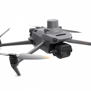
The introduction of drones such as the DJI Mavic 3 Multispectral (M3M) provides a cost effective way for operators to create high definition crop health survey maps. These can illustrate areas of significance such as weed spread and plant health to inform prescription treatments and spot spray targets.
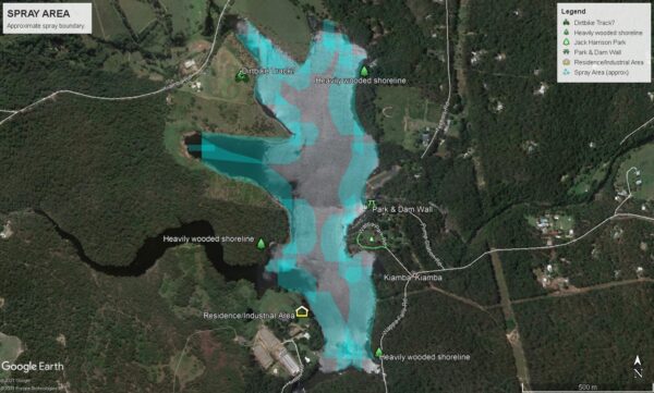
Example of a Property Map
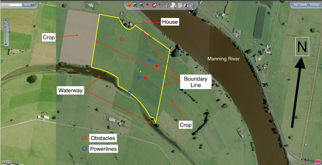
Imagery taken from SIX Maps.
The property map above clearly highlights all information of specific interest to an agricultural drone operator.
- The treatment area
- Obstacles within the treatment area
- Residential and farm buildings
- Powerlines
- Boundary lines
- Sensitive areas – neighbouring paddocks/crops
- Sensitive areas – Waterways
Using a map like this allows the operator to decide on the safest and most efficient way to treat the area. It also allows for competent consultation with the property owner/client to address any concerns about aerial application using agricultural drones.
Let’s Get Started
Don’t trust your future to anyone else. FPV Australia have you covered. Contact us NOW!